This picture was shot from atop the bridge seen in yesterday’s post. You can also see the same flock of sheep that appeared the day before that. This is my favourite shot from this roll.
Fujica GW690 & Kentmere 100 (@400) Rodinal 1 hour semi-stand development. 1+100 in 500ml of water, with a couple of extra ml of developer added.
This brick-built bridge crosses the River Idle to the west of the village of Eaton in Nottinghamshire. It’s quite a pleasant scene and there is a bench in the spot upon which a couple were sat before I took my photo. It would be a nice place to sit with a book.
Fujica GW690 & Kentmere 100 (@400) Rodinal 1 hour semi-stand development. 1+100 in 500ml of water, with a couple of extra ml of developer added.
About a week after returning from Dubrovnik, I drove to Retford (a town in Nottinghamshire about 25 miles to the east of Sheffield) with the intent of using up the last of the Kodak Gold in the camera after the holiday. It was a beautiful early summer day with blue skies and fluffy cumulus clouds.
I parked the car in the town centre (where I had to scrounge a pound from a passerby as the parking meters didn’t take card payments and I didn’t have enough coins) and then headed out to where the canal passes to the east of the town. From there I took a leisurely walk westwards along the Cuckoo Way, making a number of photos, a selection of which are included below. Eventually I left the canal and took a few more pictures on my way back into the town centre, but I’ll post those tomorrow.
Canon Sure Shot Z135 & Kodak Gold. Lab developed. Home scanned and converted with Negative Lab Pro.
The River Idle runs for 26 miles through Nottinghamshire, eventually discharging into the River Trent at West Stockwith. It’s source is a confluence of two smaller rivers, the Maun and the Meden near Markham Moor, just beside the busy A1 road.
While there are a number of suggested sources for the Idle’s name, the origin is not confirmed.
I took this photograph of the river where it flows through Retford, beneath the chesterfield canal, which crosses it on an aqueduct. On this day, the weather was very nice, and the light cast upon and through the waters, illuminating the riverbed and long streamers of gently twisting water weed.
Yashica Mat 124G & Fujifilm Pro 400H. Lab developed, home scanned and converted with Negative Lab Pro. Converted to B&W in Lightroom.
This is the second of my “Walk With a Camera” series, and a hike I plucked from the routes available on the excellent Ordnance Survey app. West Stockwith is a location I’ve had earmarked for a visit for a while, so finding a circular walking route on the app sealed the deal, and I set off on a pleasant Sunday in March to see what I might find.
The route is an easy one, being less than five miles in length and with an uphill elevation of only 85 feet.
West Stockwith is a village in Nottinghamshire which sits beside the River Trent. It’s sister, East Stockwith, sits on the opposite bank, although there is no easy way to travel between them. A ferry used to operate, but the service ceased in the 1950s. A journey south to Gainsborough, where the closest bridge stands, is the quickest route.
West Stockwith also marks the location where two other waterways join the Trent. The River Idle would form part of my route on the westbound leg of the walk, and the Chesterfield Canal would return me back east to where I started. These waterways once provided industry for the village, but traffic along them in modern times is leisure based.
As the River Trent is still tidal at this point, there are a number of barriers in place to allow water levels to be managed and to allow passage for boats. This entrance sluice is the final barrier before the River Idle enters the Trent.
After photographing the sluice gate, I set off along the footpath that follows the Idle to the west. The initial part of the footpath squeezes past a riverside property and is not immediately apparent. This Google Streetview image shows the entrance under the arch beside the blue door.
A little further upstream beyond the sluice is a pumping station which not only helps manage the water levels on the Idle, but also provides passage for river traffic. Indeed, the whole stretch of river between the pumping station and the sluice can act as a single large lock allowing multiple boats to traverse between the Trent and the rest of the Idle at the same time.
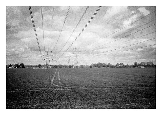
Past the pumping station, the footpath follows the river from atop an earthen flood bank, the river to the south and open fields to the north. A series of powerlines cross these fields, running from West Burton and Cottam Power stations to the south (although both are now scheduled for demolition, at least in part).
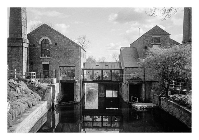
Before too long the sight of two large chimneys comes into view on the far bank of the river.
A short while later, there is a bridge across the river which then took me back east a short distance before I turned south along a lane that passes the building with the chimneys. Once a pump house, this is now a posh-looking residence named the Pump House Art Studio that is available to rent for short stays. The water flowing beneath the structure is not the River Idle, but a man-made channel named the Mother Drain.
The lane heads southwards through a couple of 90-degree bends, dips under a railway bridge, before entering the eastern side of the village of Misterton. After passing an interesting looking residential home, the route of the walk heads further into Misterton before turning off the roads and back into some fields to the north of the village. The path skirts the village for a while before re-entering it at it’s north eastern side and onto a pleasant looking road.
Walking south down this road brought me to a junction with a saddlery on one of the corners. I don’t see many saddleries in the city where I live, so it was worth a photograph, especially with the horses head stuck on the front of the building. Being a Sunday afternoon, the place was closed, but I can imagine there being an interesting display behind the shuttered window.
Across the road from the saddlery is the village church, which is where I’ll continue in part 2…