Occasionally on this blog I will post a photograph without saying anything about it. I could try and bluff my way through this and claim that “the picture speaks for itself“, or something similar, but that would be – pardon my French – bullshit.
What it actually means is, usually, one of two things:
I have writer’s block and can’t think of anything to say.
I don’t have time to write anything.
Option 2 is the usual culprit. I’ve either been doing something that has kept me from the computer, or I’ve been doing something else on the computer (or PlayStation…) and the time has gotten away from me. Either way, the result is the same, a picture without words.
Today was going to be a similar thing, but then I wrote this.
So here’s a picture that has words, they’re just not connected to its contents whatsoever…
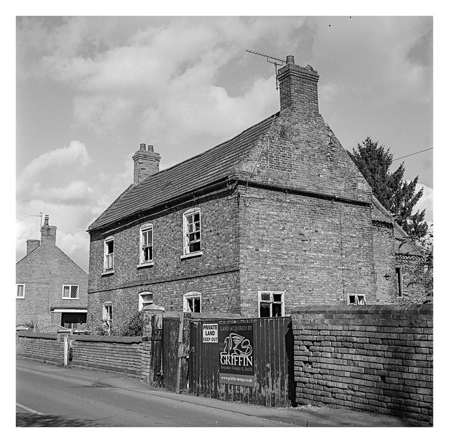
This is the same house that I shared a picture of yesterday. It definitely needs some TLC, but I imagine it will be worth a fortune when renovated.
Those two black specks at the top of the picture are birds. I ummed and aahed about painting them out, but decided they were there when the picture was shot, so there they can remain.
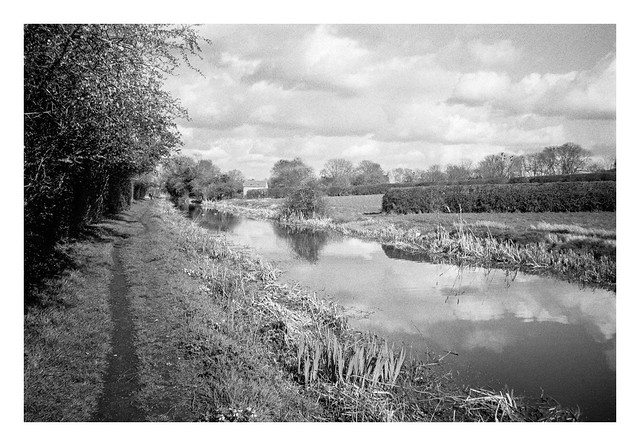
This is my favourite photograph from my walk between West Stockwith and Misterton. I presume this particular bridge is for farm traffic as there is no road atop it, just grass when viewed from Google Maps.
I spotted the composition as I approached the bridge, and then moved around a bit until it looked just right in the viewfinder. I was expecting the arch of the bridge to render more darkly, assuming the camera would meter on the brighter area in centre of frame, but it captured the reflected light from the ripples on the canal beautifully.
The first part of this post detailed the walk from West Stockwith to Misterton. This part covers the walk though the rest of Misterton and back to my starting point.
I’ll begin with All Saint’s church, a Grade 1 listed building that dates back to the 13th century (although it was largely rebuilt in the mid-19th century. It was a little awkward trying to compose a shot of the church from the entrance to the grounds to the east (the perils of a fixed-lens camera), but a better view was possible from the west, albeit with the church partially obscured by a couple of evergreen trees.
I sometimes go inside churches if they are open, as there is usually something of interest to look at and photograph, but I didn’t have time on this trip. Instead I took the following picture of one of the stained glass windows from the outside. This is perhaps not the best way to appreciate stained glass, but I quite liked the patterns of the lead-work.
Leaving the church along Church Lane, I rejoined the main road through Misterton (the B1403). The road changes names from Church Street to Gringley Road near here and an old-style black and white fingerpost donates directions to various places. I think this one is ready for a lick of fresh paint.
Following Gringley Road south passes a variety of interesting old houses before reaching a bridge that crosses the Chesterfield Canal. It was here that I left the road to join the Cuckoo Way footpath that follows the canal all the way from its source in Chesterfield in Derbyshire.
The canal skirts the southern side of Misterton, passing beneath a few bridges, such as this one that carries Grovewood Road.
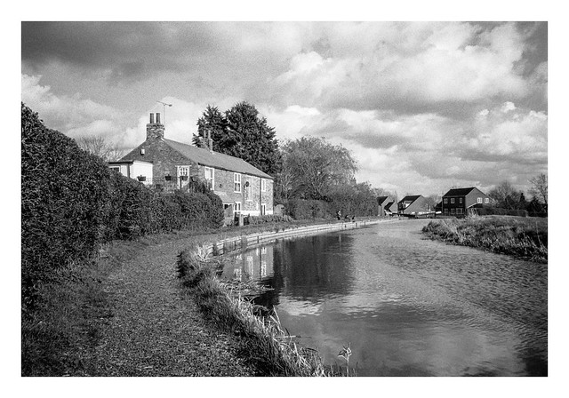
Further down the canal, it curves attractively past some houses where a man and two boys were fishing, before reaching a series of locks. One of the houses between these locks had a small boat moored beside it’s back garden
The canal then follows a straight route back towards West Stockwith. There were many narrow-boats moored along this stretch.
There’s a final bridge carrying the main road through West Stockwith before the canal enters Stockwith Basin, a marina that opens directly into the River Trent via locks.
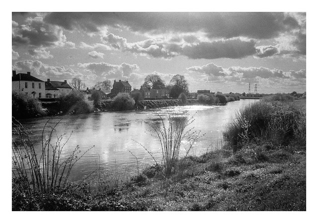
The final stretch of the footpath route follows the flood-bank on the west side of the Trent. The Trent is the third longest river in the UK, flowing 185 miles from its source on Biddulph Moor in Staffordshire, to Trent Falls in Lincolnshire, where it discharges into the Humber Estuary. The river is navigable to Burton on Trent in Staffordshire.
Leaving the riverbank before the mouth of the River Idle, I crossed the bridge across the Idle and back to my start point in West Stockwith.
I enjoyed this walk. The weather was pleasant, the light was nice for photography, and there was plenty to see along the way.
This is the second of my “Walk With a Camera” series, and a hike I plucked from the routes available on the excellent Ordnance Survey app. West Stockwith is a location I’ve had earmarked for a visit for a while, so finding a circular walking route on the app sealed the deal, and I set off on a pleasant Sunday in March to see what I might find.
The route is an easy one, being less than five miles in length and with an uphill elevation of only 85 feet.
West Stockwith is a village in Nottinghamshire which sits beside the River Trent. It’s sister, East Stockwith, sits on the opposite bank, although there is no easy way to travel between them. A ferry used to operate, but the service ceased in the 1950s. A journey south to Gainsborough, where the closest bridge stands, is the quickest route.
West Stockwith also marks the location where two other waterways join the Trent. The River Idle would form part of my route on the westbound leg of the walk, and the Chesterfield Canal would return me back east to where I started. These waterways once provided industry for the village, but traffic along them in modern times is leisure based.
As the River Trent is still tidal at this point, there are a number of barriers in place to allow water levels to be managed and to allow passage for boats. This entrance sluice is the final barrier before the River Idle enters the Trent.
After photographing the sluice gate, I set off along the footpath that follows the Idle to the west. The initial part of the footpath squeezes past a riverside property and is not immediately apparent. This Google Streetview image shows the entrance under the arch beside the blue door.
A little further upstream beyond the sluice is a pumping station which not only helps manage the water levels on the Idle, but also provides passage for river traffic. Indeed, the whole stretch of river between the pumping station and the sluice can act as a single large lock allowing multiple boats to traverse between the Trent and the rest of the Idle at the same time.
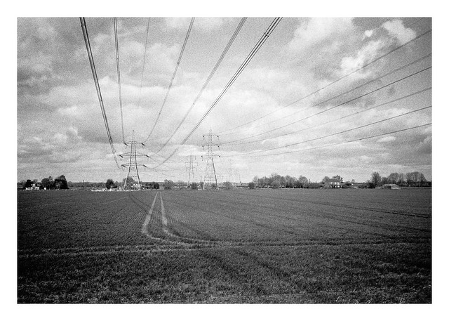
Past the pumping station, the footpath follows the river from atop an earthen flood bank, the river to the south and open fields to the north. A series of powerlines cross these fields, running from West Burton and Cottam Power stations to the south (although both are now scheduled for demolition, at least in part).
Before too long the sight of two large chimneys comes into view on the far bank of the river.
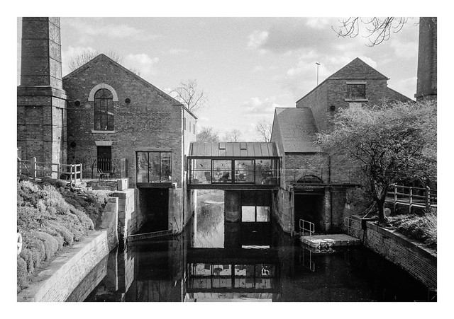
A short while later, there is a bridge across the river which then took me back east a short distance before I turned south along a lane that passes the building with the chimneys. Once a pump house, this is now a posh-looking residence named the Pump House Art Studio that is available to rent for short stays. The water flowing beneath the structure is not the River Idle, but a man-made channel named the Mother Drain.
The lane heads southwards through a couple of 90-degree bends, dips under a railway bridge, before entering the eastern side of the village of Misterton. After passing an interesting looking residential home, the route of the walk heads further into Misterton before turning off the roads and back into some fields to the north of the village. The path skirts the village for a while before re-entering it at it’s north eastern side and onto a pleasant looking road.
Walking south down this road brought me to a junction with a saddlery on one of the corners. I don’t see many saddleries in the city where I live, so it was worth a photograph, especially with the horses head stuck on the front of the building. Being a Sunday afternoon, the place was closed, but I can imagine there being an interesting display behind the shuttered window.
Across the road from the saddlery is the village church, which is where I’ll continue in part 2…