I was going to publish the second part of my West Stockwith to Misterton walk post today but I got waylaid on other important stuff (not playing Fallout 4, honest… 😉 ). I will endeavour to write it for tomorrow though.
It’s not been all videogames today though, most of the day was taken up by a trip to Bakewell with my wife as there was a food market on. Other than a couple of bratwurst’s for lunch, and some cakes from a shop, we didn’t actually buy that much food. My wife came home with a new coat though, and I bought a second-hand Ladybird book (one that I used to own as a child).
I took a handful of photos while there, although I’ll have to wait and see if any of them were worthwhile. One, at least, ought to be interesting.
So instead of photos from my second planned Walk With a Camera outing, here’s a picture of the closed post office in Eyam (which, to be fair on myself, I shot during the earlier hike I posted about here).
This structure stands on a sloping side street in Eyam, Derbyshire.
I’m not sure what the buildings are. Workshops? Outbuildings? Stables? Whatever their purpose, there was a definite air of Goldilocks about it – A Daddy Bear – Mummy Bear – Baby Bear arrangement of size. I felt it worthwhile of a picture.
Continuing from yesterday, the second part of this post will cover the leg of the journey from Stoney Middleton back to Eyam.
The footpath I had been following enters Stoney Middleton via backstreets. Where this street merges into another named The Fold, there is a sign affixed to a wall pointing the way back to Eyam to those unsure of the route
At the bottom of The Fold there is a small open area where Dale Brook flows before disappearing beneath the William Lennon and Co boot factory. The building was formerly a corn mill before William bought it in 1904 along with the Mason brothers, forming Mason Bros & Lennon, where they began repairing, and then manufacturing boots. The factory still operates and is in the hands of Williams great grandchildren, focusing on retro footwear produced using traditional techniques.
The western end of this grassy area is separated from the grounds of the boot factory, and contains a sapling planted to commemorate the Diamond Jubilee of Elizabeth II. Here also sits Toll Bar Fish & Chips, from which a very tempting aroma was drifting. I’ve had chips from here once before and they were very good, but on this occasion it was still a little early for lunch.
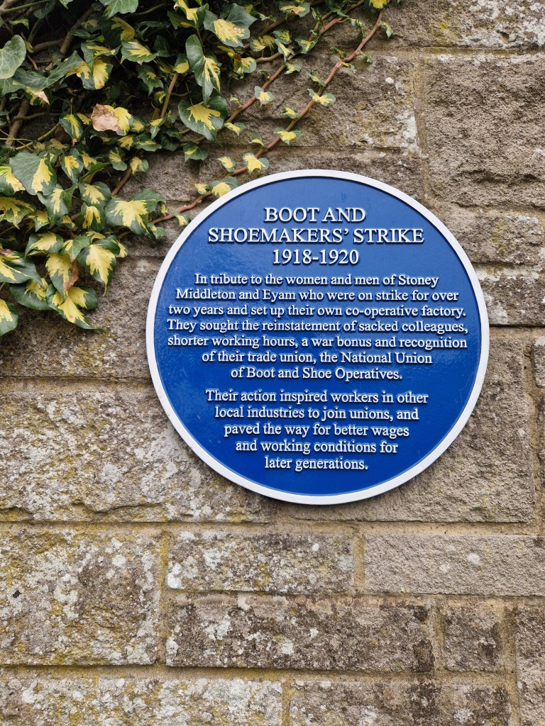
More heritage trail signs are present, as well as a blue plaque on the side of the Boot factory remembering the Boot and Shoemaker’s Strike between 1918-1920.
The next shot shows some houses across the road from the chip shop, illustrating the precipitous nature of parts of the village.
St. Martin’s church was the next landmark on my walk. The church was open to visitors and I went inside and made a few pictures with my Yashica Mat 124G, which I’ll post on another occasion. The church is quite unusual in that the nave is octagonal, which you can just about make out in the picture below.
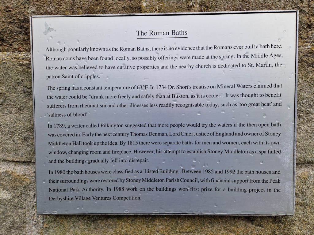
On the road past the church is a small building with a spring flowing beside it. The structure is known as the Roman Baths. I didn’t photograph it, but grabbed a quick picture of the plaque outside with my phone camera.
At the end of this road the tarmac ends and I was back onto a track again. Near the bottom is a cemetery containing Commonwealth War Graves. It has a mossy lychgate that made for an interesting picture.
From here the track, and old packhorse trail, ascends quite quickly. It’s rocky and bumpy and soon had my legs aching and my lungs panting. The next photo is looking back the way I came. This section was a bit less steep.
At the top of this track is a road, and there is a footpath through the fields on the other side that continues the ascent. Again, this next shot was a look back the way I had come.
At the top of this path is a wooded area with the trail eventually joining Riley Road. This road runs back towards Eyam and is thankfully downhill all the way, but near the top it passes a field which is the site of the Riley Graves. This small enclosed graveyard contains the gravestones of seven members of the Hancock family who lost their lives as a result of the plague within seven days of one another in August 1666. Elizabeth Hancock buried her husband and six of her children here. After the plague passed, Elizabeth moved to Sheffield with her remaining son.
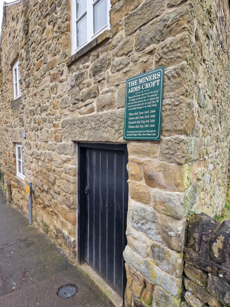
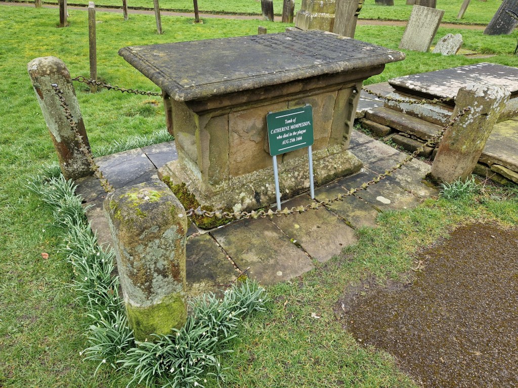
Many of the buildings and places in Eyam have information plaques affixed, providing information on the events of the plague, such as these at The Miner’s Arms and within the parish church graveyard.
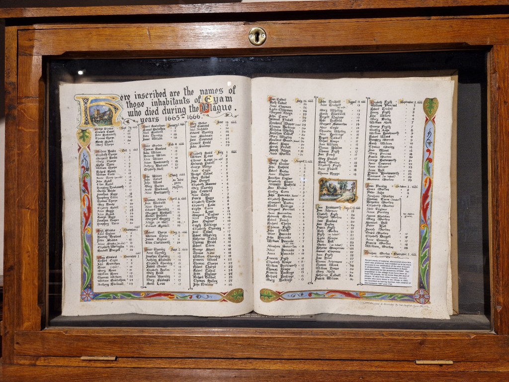
Within the church can be a found listing the inhabitants of the village who fell victim to the plague.
On that sad note I’ll bring this two-part post to a close. I plan on doing a bunch of these walks this year (indeed, I’ve already done three more!), so look out for those soon.
This year (and hopefully more to come) I’m planning on taking a bunch of walks / hikes with a camera. This is not a particularly new idea – I do this all the time already – but my methodology previously has been more based on random choice. Not quite stick a pin in a map, but certainly unguided insofar as points of interest on the walks I chose. Some of these self-directed walks were good and there were plenty of things to see along the way (and it’s always great when you come around a corner to find an interesting scene before you). But I’ve also been conscious that I might have been missing out on stuff that I would have seen if I’d only gone by a different route.
So the hikes I’m undertaking this year are based on guidebooks, or the recommended walks that can be found in the Ordnance Survey (OS) app that I subscribe to. Some of the walks are quite short – just a few miles – while others are longer, although none are too taxing, and nothing that can’t be achieved within the course of a day out.
I’ve also started to purchase some equipment for these outings. I’ve discovered how uncomfortable the wrong clothing can be in the right conditions. I want to be able to keep warm or cool as appropriate, and be able to stay dry in the UK’s changeable weather, so I’ve been investing in some proper outdoor clothing – base-layers, mid-layers, waterproof shells and the like. I’ll probably have to buy more stuff as the conditions change through the year, but at the end I should have a wardrobe of clothing to suit most conditions that I’ll encounter. I’ve also bought a pair of hiking poles. I wondered if these might have been overkill, but the first time I used them they were a godsend.
One thing I want to buy is a good quality backpack. Not necessarily a photography backpack, but one that will serve that purpose as well as giving me space to carry other provisions. Until then I’ll make do with the backpack I already own.
Anyway, this has been a somewhat lengthy preamble. TLDR – I’m going to go for some walks, take pictures along the way, and write about it here. 🙂
The initial hike I chose is the first walk in my OS Peak District Outstanding Circular Walks book: Eyam and Stoney Middleton.
This first walk sits in the “short walks” category of the book, with hikes of less than 2.5 hours (although I don’t think they accounted for photography in those timings 🙂 ). It’s only 3.5 miles, with a height gain of 660 feet (although, to be fair, that gain is pretty much all in one leg-busting uphill section).
The day of the hike was typically British overcast weather. This isn’t the sort of day that inspires photography to be honest, but I’ve also decided hereon that I will make the best of the conditions I have rather than take my usual approach of moaning about it, so it was on this damp and grey day that I arrived in the village of Eyam to begin my walk.
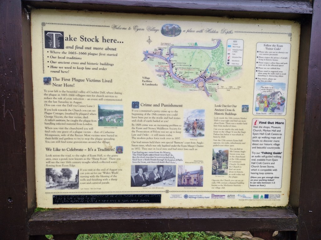
There is evidence of human settlement at Eyam dating back to the Ancient Britons but it was in the 17th century that the village gained fame. In 1666 the Great Plague of London, an outbreak of Bubonic Plague, took place. During the outbreak a bolt of cloth containing infected fleas was delivered to the tailor in Eyam, resulting in a local outbreak of the disease. Although there is some debate about the numbers affected, nearly three hundred villagers are recorded as having lost their lives as a result. A number of measures were introduced by the village to attempt to halt the spread, including a requirement that families isolate and bury their own deceased members. The most important however, was likely the decision to quarantine the entire village to prevent outside transmission. It is this sacrifice that give Eyam its fame.
I began my walk down Church Street, the main road through the village. It’s lined with houses in a variety of styles, from stone built cottages, through to the grand looking Eyam Hall, which now serves as a wedding venue.
A map, an information board, and a set of stocks sit just to the right of frame in the image above.
Eyam Hall probably looks nicer in good light, but it’s still an impressive presence on a dull day.
A village shop is present and doing business, but what I assume to be the post office was closed.
The door to the Mechanic’s Institute was open and there was some activities taking place inside (although not mechanics, I don’t think).
Further down the village I reached the point where I would take a right onto Lydgate and head along the footpath that leads to the neighbouring village of Stoney Middleton.
The footpath was a little muddy on the day, and I was glad of my hiking boots, but it was easy to traverse. Not far out of Eyam I could see the ruin of a farmhouse in the middle of a field.
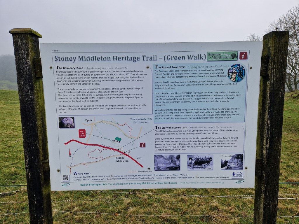
A little further along the track sits the Boundary Stone. This boulder was used to exchange money for goods between the villages of Eyam and Stoney Middleton. There are a number of holes in the top of the stone and these were filled with vinegar in order to sterilise the money.
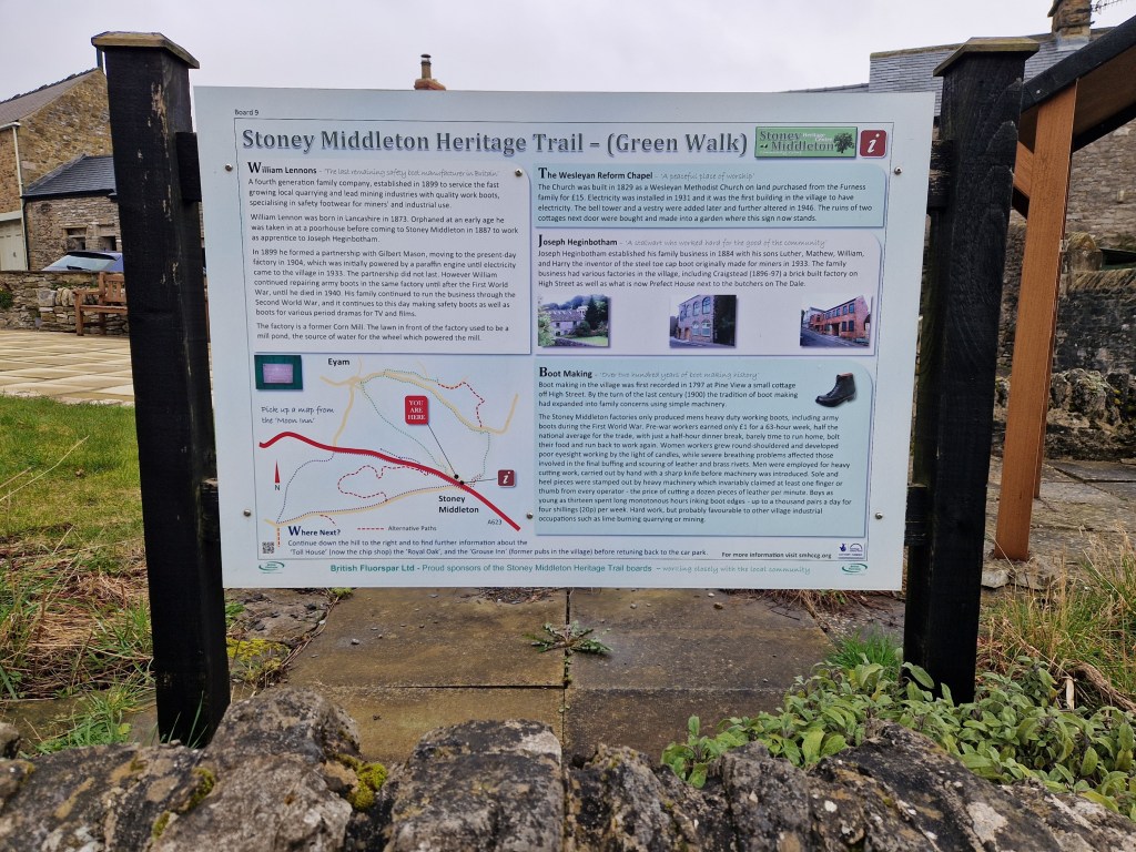
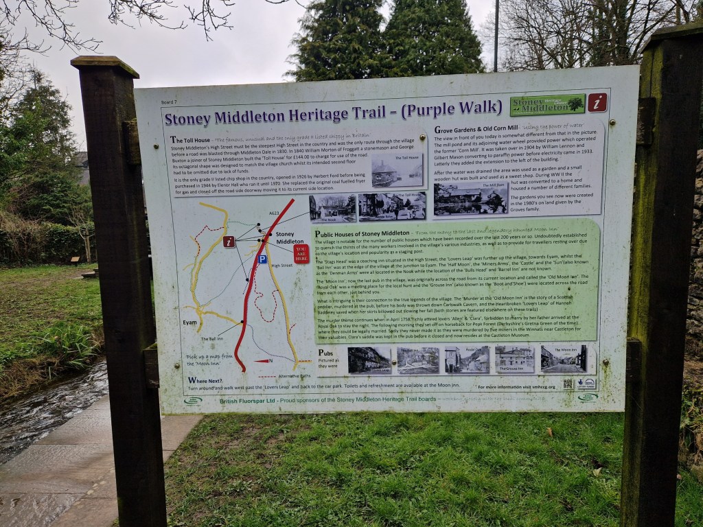
There are a number of information boards present along this footpath, denoted as the Stoney Middleton Heritage Trail, which contain interesting facts along with some tragic stories.
As the footpath crests the ridge before a steep descent to Stoney Middleton, a tree had fallen. It’s surprising how little of a tree’s structure is underground sometimes, and this one had it’s work cut out to find purchase for so long in the stony soil.
I’ll end this first part of the post with a picture of the path down into Stoney Middleton, which you can just see emerging from the murky day at the bottom.
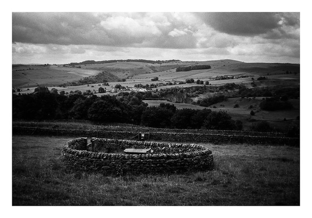
Just to the east of the village of Eyam lie the Riley Graves. This is a small cluster of graves (six in all) surrounded by a drystone wall. Depsite the name, the graves are of the Hancocke family, who all lost their lives to the plague in between the 3rd and the 17th August 1666. The name of the graves comes from Riley’s field, which is where they are situated.
The postman makes his rounds in the village of Eyam.
Someone commented that this picture has quite a vignette, and I guess it does – I tend to add a vignette to most of my pictures in post processing, although I don’t go overboard with it. This doesn’t have any more vignetting than the others I post but it does look more noticeable (although I don’t mind). I think it’s partly down to the two areas of blue sky at the upper corners of the photo that serve to emphasise the vignette more than if it were just white cloud.
Perhaps not concrete, more stone and cement, but this encroaching ivy is making a good job of claiming this cottage. The side door has already been blocked and the window will not be far behind.
Another picture from the lane near Eyam. I was on my way back to the start point when I took this one and the track made a short twist here. I’m not sure why – I couldn’t see anything that would physically require the bend, but who knows what might have been there in the past – either trees, or maybe different ownership of plots of land or something?