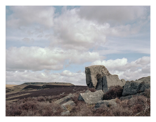
I crunched through the dry, brown heather to get this cluster of rocks in the right place to frame this landscape photo of the moors looking over to Higger Tor, which can be seen in the distance at centre-left. It was approaching lunchtime when I made this picture – long after the golden-hour had passed – but there’s something to be said for capturing images at this time of day. It’s often the time and light when people are out and about and so depicts scenes as many of us will usually see them
Tumbled and jumbled Boulders litter the landscape On Peak District moors
Bronica ETRSi, Zenzanon 75mm f/2.8 PE & Kodak Portra 160.
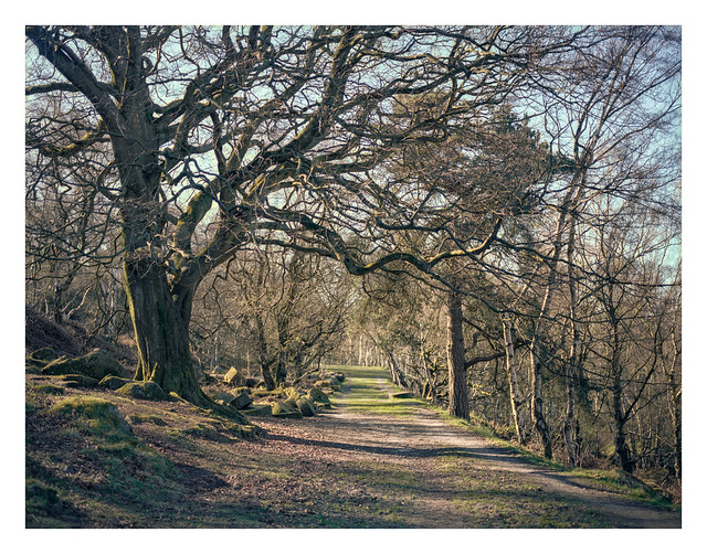
This is the track that leads to Bolehills Quarry. On the left, just beyond the tree, you can see a stockpile of abandoned millstones. Presumably this is where they were stored before being transported elsewhere, and here they remain since the market fell away, gathering coats of moss and lichen and providing something nice to look at as you pass by.
Abandoned millstones Lining the route to Bolehills In the spring sunshine
Bronica ETRSi, Zenzanon 75mm f/2.8 PE & Kodak Portra 160.
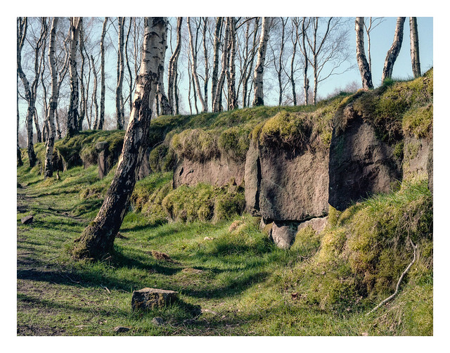
Bolehills Quarry, up above Padley Gorge, is carpeted with lush grass and beautiful silver birch trees. It’s a location that likely suits pretty much any type of conditions. The trees cast stark shadows in bright light and look mysterious in mist. These two shots were made around 9-10am while the sun was still striking long shadows.
I scanned these using EpsonScan, which is not something I normally do with colour photos as I’ve been less than successful at getting nice colours from the results in the past. This time though, I think it’s worked very well. Maybe not perfect – I doubt I’ll ever be sure a colour scan is “perfect” – but still a result I’m very happy with.
The Bolehills birch trees White trunks cast shadows on green In the morning sun
Bronica ETRSi, Zenzanon 75mm f/2.8 PE & Kodak Portra 160.
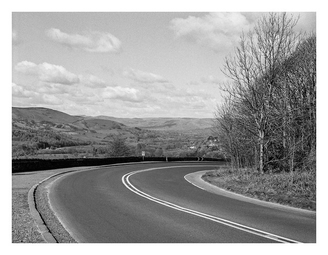
This is the A6187 road at Hathersage Booths, before curving and descending into Hathersage itself. It has a wonderful overview of the Hope Valley stretching into the distance with Mam Tor (the “Shivering Mountain”) just coming into view as part of the distant peaks. Mam Tor translates as “Mother Hill” and is so named because one side of it is prone to frequent landslides. The resultant debris has given birth to a number of smaller hills on the lower slopes.
Into Hope Valley A beautiful view to see During the descent
I’d estimate I was perhaps halfway up the side of the valley when I made this photo, climbing from the River Derwent at the bottom up to Over Owler Tor – the highest point on my walk that day. The house that can be spied beyond the gate sits on the main Sheffield to Hathersage road.
Thighs aching, I walk My ascent up the valley To my origin
This follows on directly from my post a couple of days ago about my walk over the fields near Aston. Another four photos from the middle(ish) section of the walk.
It was dry on the day of the walk and the ground was firm, but there were reminders of how the conditions can change when wet weather has occured, both in the shape of these tractor tracks, and also the signs of footprints in the dried surface of the footpath.
Across another field the path splits – turning right and heading south along the western edge of the mortorway, or left where I walked up an incline to the bridge across the M1. Just before crossing the bridge I made a photo of a farm track where it ran through a stand of trees.
Crossing the motorway in the crisp spring light, I made another picture, this time of the road heading north. A little further up is the junction where the M18 splits to take drivers north-east to Doncaster, Robin Hood Airport, and on to Goole. The M1 itself bends westwards to split the gap between Sheffield and Rotherham, crossing the River Don over Tinsley Viaduct close to the Meadowhall shopping mall, before turning back north to Barnsley, Wakefield and Leeds.
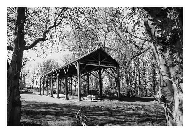
After crossing the motorway, the footpath cut to the right and south towards a nearby farm. The farm had a large open-sided barn which made opportunity for another couple of pictures.
I did make one final photo on this roll of Delta 100 a little further on where a line of poplars framed a nice wooden door and cottage. Sadly the film snapped while loading it onto the spiral and so that frame was lost.
I’ve more photos still to come from this walk, but they’re colour pictures so I’ll post them another day.
A big wooden barn It’s sides open to the wind Contents blown away?
A week ago I posted a couple of photos of trees stood beside a drystone wall at the edge of Padley Gorge. In that post I mentioned that I had another photo made at the same location yet to come, so here it is today.
A gap in the wall Reveals an excited birch Waving its branches
A couple of weeks ago I went for a walk along a previously unexplored path. The route took me from Aston, a village / district on the easternmost edge of Sheffield, north over the fields towards Penny Hill Wind Farm, then cuting to the east to cross the M1 motorway on a farm bridge. From there, back towards the south, across the M1 at the busy Junction 31 roundabout, and through Aston again to where I began.
There will be a number of photos to come from this walk in the next few days and I shot both black-and-white and colour images. Today’s post features a quartet of photos from the first half of the walk.
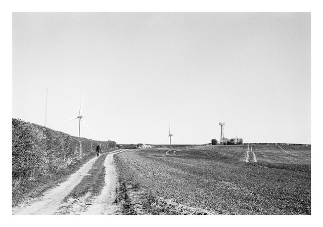
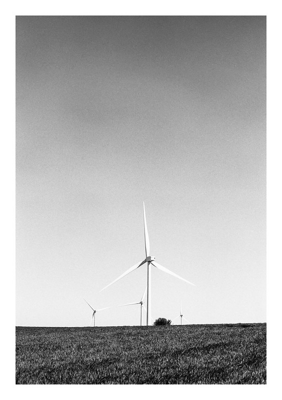
This first image is the lane from Aston down to a farm at the bottom of the dip. In the distance, at middle-left, one of the large wind turbines at Penny Hill can be seen peeking above the trees.
Climbing the hill past the farm up to the top of the ridge brings the turbines into more prominence, as well as a mobile transmitter and another antenna of some sort over on the left of the frame – at night this one can be seen lit with red aircraft warning lights.
Approaching the mobile tower, the turbines now take prominence along the top of the ridge, although they are still quite some distance away.
Heading east across the fields towards the nearby motorway, I turn and make a photo of the path along which I have walked.
Out across the fields Feeling the bite of the air Crisp and cold and bright
Owler Tor stands a mere stone’s throw from Surprise View carpark. Unlike its namesake Over Owler Tor which sits up on the hillside in the opposite direction, Owler Tor is accessed by simply crossing the road, passing through a wooden gate, and then walking to the nearby boulders.
On nice days and, especially, weekends it’s difficult to get a photograph that doesnt have at least one person in the frame. The main part of the tor is easily climbed and there are generally groups of people taking in the view and grabbing selfies from the summit. There were a few people around when I made the shot featured here today, but patience, timing, and that old standby – the awkward photographer’s stance – allowed me to keep them out of the frame.
Climbing Owler Tor An irresistable draw For its visitors