
One of the ways I like to find potential locations for photography is by browsing Ordnance Survey maps. Usually I look for public footpaths and rights of way and plan a walk in the hope that there might be something interesting to photograph along the route – usually there is. I’ve loved to look at Ordnance Survey maps ever since I first came across them as a child – specifically the 1:25,000 scale Landranger maps. They’re a treasure trove of detail with their beautiful design and iconography, and just skimming across them will turn up evocative little identifiers for things like trig points, towers, tumuli, wells and all manner of other intriguing things. And so it was on this occasion, where my browsing alighted upon the intriguingly named Hell Bank Plantation which also had a little marking stating “Waterfalls“.
So last Saturday, after my walk along the River Derwent at Calver, I decided to head home via a route that would take me to Hell Bank Plantation so I could see what it was like as a location.
After a wrong turn that would have gotten me where I needed to go – if I was on foot(!) – I finally took the right route and managed to get a parking space at the top of the plantation (where a decent number of other vehicles were already parked). The entrance into the plantation was via a stile a few yards from where I’d parked and the trail led down into the pine woodland. After a short distance the main footpath had a fork with the narrower branch heading down towards where I assumed the stream and waterfalls would be.

The path led me across the stream and then took a left turn so that it descended into the valley with the stream on my left, now at the bottom of a steep-sided gorge. I could see a number of cascades of water down there – nothing spectacular (although I guess it will be much more exciting after some heavy rain) but attractive nontheless. After walking down the valley a couple of hundred yards, it became apparent that there was no easy way to get to the stream from this path down here so I back-tracked. Back near the top I found a place where, with care, I might get down to the water. So, using my tripod as a walking pole, I eased myself down the steep bank to the bottom.

Near the bottom was the remains of a stone bridge about ten feet wide, broken in the middle and covered in moss. Thankfully, it also looked like there might be an easier way back up the opposite bank when I finished with my photography. I made my way upstream a little to get in position for some photos – while the stream wasn’t a torrent, there were still some pools that were plenty deep enough to submerge my walking boots fully, so careful progress was required. When I found a good spot I took an incident meter reading and also a couple of spot readings of shadows and highlights to see what they would show (the average wasn’t too far off the incident reading, so I went with that). As I wanted to try and get everything in focus, I metered for f/22 which gave an exposure of around 2 seconds.

After taking a number of shots I retreated to the broken bridge and, as I’d hoped, was able to climb the eastern bank with relative ease and from there walked back uphill to the car and the journey home.
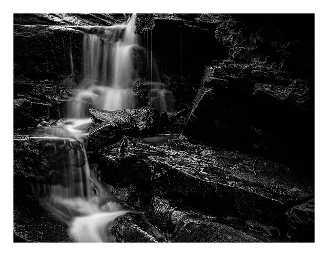
The processed negatives were a little on the thin side, although not unduly so, and I’ve ended up with contrasty images that I like – at least where the stream and cascades of water are concerned. Some of the other shots (including the bridge) are somewhat busy and I think, if I return to the location, it deserves colour to properly seperate the vegetation, rocks, water and wood textures in the pictures.
There is also another waterfall further down the valley according to Ordnance Survey. 🙂
Bronica ETRSi, Zenzanon 75mm f/2.8 & Kodak Tmax 400.
Taken on 25 January 2020
